Reading, references and study questions for lecture 18-20 - click here
This set of three lectures concerns the processes that set water properties such as temperature and salinity in the surface layer, and then how these waters move into the ocean interior. We concentrate here on the upper ocean, down through the thermocline, with some reference to the intermediate layer. The deep waters - formation and circulation - are the subject of later lectures.
The surface layer is mixed through two processes: (1) wind stirring and (2) convection driven by cooling and/or evaporation. It is restratified after mixing through two processes: (1) warming and/or precipitation from the atmosphere/sun and (2) advection which moves layers or parts of layers around and restratifies the mixed region.
The mixed layer properties that matter for the large-scale distributions throughout the interior ocean are the late winter mixed layer properties. "Late winter" is February/March in the northern hemisphere and August/September in the southern hemisphere, at the very end of the cooling season. Late winter properties are most important because the mixed layers are deepest in late winter (due to cooling), and then restratify from the top down during the heating season. This leaves a "remnant" winter mixed layer behind during most of the year except in late winter. The remnant winter mixed layer is free to move off through advection, and might end up somewhere where it is not accessed through vertical mixing during the next winter.
Wind stirring extends only to several tens of meters, probably at most to about 100 meters. The wind creates turbulence through breaking surface and internal waves, inertial oscillations, and exotica such as Langmuir cells. The turbulence and hence mixing is stronger when the wind is stronger. The depth of mixing depends on the strength of this turbulence and also on the pre-existing stratification. When a layer is mixed by the wind, there is no change in heat, salt or buoyancy content, and so the properties of the mixed layer are an average of the properties of the initial stratified layer that is mixed.
Convection can mix the surface layer much deeper than can wind. (It can also mix it much more shallowly, if the removal of buoyancy at the surface due to cooling or evaporation is small.) The depth of convection depends on the loss of buoyancy at the sea surface (amount of cooling or evaporation), and the pre-existing stratification. If conditions are good for convection, it can reach to more than 1500 meters. This occurs only in a few places in the world. (See lecture on deep water formation.) Late winter convection, after cooling has acted for as many months as possible, usually results in a more common thickness of tens to several hundred meters depending on the ocean and region.
The full convection process has three phases: (1) pre-conditioning, (2) convection itself, and (3) restratification. Pre-conditioning means that the ocean circulation and/or eddies create conditions that are more favorable for convection, for instance by doming isopycnals upward in a region of strong cyclonic flow. Or pre-conditioning can occur in regions on the warm side of strong currents such as the Gulf Stream or Antarctic Circumpolar Current (Subantarctic Front), where isopycnals are much more spread apart, hence lower stratification, than within or on the cold side of the current.
Convection itself occurs in cells that are small in the horizontal - about the same width as they are high. Thus the aspect ratio (H/L or height/width) is order 1. Actual convection cells, which are no more than about 1 kilometer across, are usually embedded in a larger region that is favorable to convection. Such regions are often several hundred kilometers across, and have at least several convection events within them. Vertical velocities within convection cells are almost as much upward as they are downward - the cells overturn rather than convey a large amount of water downward or upward. Net transport is downward across isopycnals, but might not be downward in physical space.
When convection occurs at many localized sites within a larger convection "patch", the whole region of the patch becomes denser than the waters outside it. This creates doming isopycnals over the patch, which creates a nearly geostrophic shear.
Restratification occurs when the sun warms the surface layer (penetrating down to about 50-100 meters itself). It also occurs through breakup of the geostrophic or nearly-geostrophic flows that build up during the convection process. It can also occur through simply mixing waters from the convection patch with waters from outside it due to eddies which might not be associated with the convection patch spinup.
We consider in this set of lectures two processes that move waters from the surface into the interior: (1) restratification after convection, and (2) subduction.
Restratification after convection was discussed above. A simple way to look at it is that convection spreads out isopycnals vertically as the water mixes. Restratification tries to restore the isopycnal spread to something that is more flat. In the process, the convected water becomes isolated from the sea surface, and is therefore part of the interior. It is then free to circulate away from the convection region, and might not be subjected to further surface processes. (In some regions though it might indeed be subjected to further surface processes if it is too light to sink beneath the surface layer.)
Subduction is a term borrowed from plate tectonics. It is the process where relatively dense surface waters, say on the poleward side of a subtropical gyre, are circulated towards a region where the surface waters are less dense, say on the equatorward side of a subtropical gyre. Rather than push the less dense waters aside, the denser surface water sinks (at a very small angle relative to horizontal) beneath the lighter waters, and thus leaves the sea surface. Seasonality is an important concept for subduction. As described at the beginning of these notes, the late winter mixed layers are "capped" or restratified by heating in the following season, and then might be moved out of their region by the circulation. If they are moved to a region with milder winter cooling, then they will not re-open to the atmosphere the next winter. They have thus joined the interior of the ocean.
Subduction is an isopycnal process (flow along isopycnals). It is manifested in the distributions of many tracers along isopycnals which outcrop in the subtropical gyre.
The density range of subducting waters extends to the maximum density which outcrops in the subtropical gyre, that is, along its northern boundary with the subpolar gyre. In the North Pacific, this maximum subducting density is around 26.2 sigma theta.
The "water masses" that are created by subduction are the Central Water (water in the thermocline, spread along a continuous temperature/salinity range), and Subtropical Underwater (salinity maximum arising from subduction of the very high central subtropical gyre waters beneath the fresher waters which lie to the south).
Subpolar gyre processes. There is no subduction in the subpolar gyre in the same sense as in the subtropical gyre since it is a region of upwelling rather than downwelling. (This has been referred to as a region of "obduction", where the water comes up rather than subducting, or going down.) Surface densities are higher in the west than in the east, and are highest in the northwest corners of both the N. Atlantic and N. Pacific. Because of the cyclonic circulation, isopycnals dome up towards the center of the SP gyres. This leaves the thicker layers on the outside rim of the circulation. In the N. Atlantic, these thicker layers are relatively easy to mix deeply, leading to a progression of very thick surface layers around the outside of the gyre. In the N. Pacific, there is thickening, but the mixed layer depths are strongly constrained by the very fresh surface waters, which keep the subpolar region well stratified.
For the upper ocean (these lectures), we consider the following water masses, along with their location and dominant formation process:
We don't consider the complicated water mass structure of the tropics, nor do we consider the water mass structure of the near-coastal regions.
Subtropical mode water in the N. Pacific . In the western subtropical North Pacific, the main thermocline (pycnocline) is interrupted by a "thermostad" (pycnostad), which is a region of lower vertical gradients of temperature, salinity and density, compared with the thermocline above and below. Such a thermostad is typical of the major subtropical western boundary current recirculation regions in each ocean. This pycnostad in the North Pacific is referred to as "Subtropical Mode Water". "Mode" means relatively larger large volume on a volumetric T-S diagram (illustrate). This name was introduced by J. Masuzawa in 1969, and has been applied to the similar water masses in the other four subtropical gyres.
The STMW in the North Pacific is in the temperature range 16-19C and is found just south of the Kuroshio Extension (Masuzawa, 1969). The temperature of the thick layer decreases eastward. This region is subject to two processes which could contribute to the thickness of the mode water: large winter heat loss due to the advection of warm water into the region combined with cold, dry air blowing off the continents, and the tilt of isopycnals in the Kuroshio Extension and recirculation which creates a "bowl" of warm water between the Kuroshio Extension and the recirculation. (The isopycnal tilting is of course associated with vertical shear of the horizontal geostrophic currents.)
Figure. Potential temperature at 149E (WOCE section P10) and Sigma theta at 149E (WOCE section P10) illustrating the North Pacific Subtropical Mode Water just south of the Kuroshio.Subtropical Mode Water ("Eighteen Degree Water") in the N. Atlantic. The STMW in the N. Atlantic is associated with the Gulf Stream. Since it is centered around a temperature of 18 degrees, it is often referred to as 18 Degree Water.
The isopycnal bowl immediately south of the Gulf Stream created by the Gulf Stream itself and its westward recirculation south of the Gulf Stream is a site of winter convection. Convection is favored here for two reasons - the isopycnal bowl has reduced vertical stratification compared with other regions simply because of the bowl, and heat losses to the atmosphere in this region are very large because of the conjunction of the warm Gulf Stream waters and cold, dry air blowing off the North American continent. The convected water mass is called "Eighteen Degree Water" because of its dominant temperature. It is the Subtropical Mode Water that is associated with the Gulf Stream. (Recall that there is an STMW for each of the subtropical gyres' western boundary currents.) The Eighteen Degree Water is spread by the circulation into the whole of the western subtropical gyre, even though the only location where it outcrops is close to the Gulf Stream. It is recognized far from its source as a vertical maximum in thickness between isopycnals, which results from the initial convection.
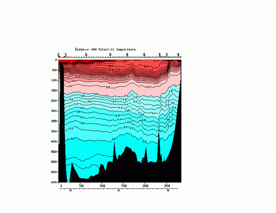
Potential temperature at 64W (crossing the Gulf Stream, showing 18
degree water).
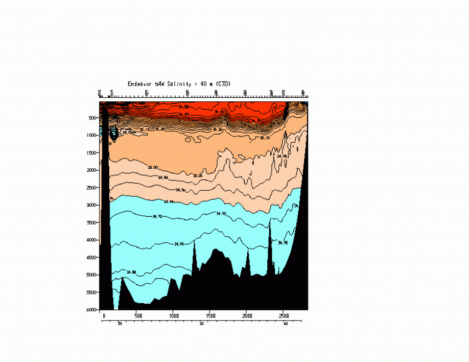
Salinity,
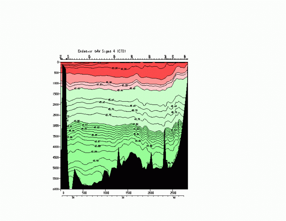
Potential Density (0 dbar),
Potential Density (4000 dbar)
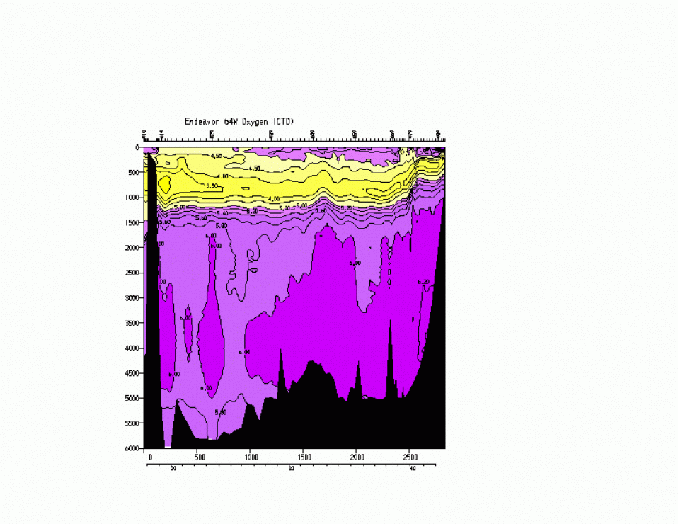
Oxygen (ml/l)
Subtropical mode waters in the southern hemisphere. The Brazil Current, Agulhas Current and western South Pacific subtropical gyre (eastward extension of the East Australia Current) all have documented STMWs. As in the N. Atlantic and N. Pacific, they are around 16 to 19 degrees C. They are all found on the equatorward (northern) side of the strong current front that has separated from the western boundary. The similarity in temperature of the five STMWs is likely a of consequence of the similarity in the latitude where the western boundary currents separate from the coast. (This similarity in turn is due to the similarity in the wind and wind stress curl patterns.) Since the surface temperature distribution is approximately symmetric about the equator, with similar temperatures at similar latitudes, the STMWs, which are formed at the surface, have similar temperatures.
Subpolar Mode Water. In the North Atlantic's subpolar gyre, the winter mixed layers are quick deep, > 400 meters and up to 1500 meters in the Labrador Sea. These thick layers are called Subpolar Mode Water, in analogy with the Subtropical Mode Water of the subtropical gyres. SPMW temperatures range from about 14C near the North Atlantic Current, to 8C where SPMW enters the Norwegian Sea, to 4C where SPMW enters the Labrador Sea. (Figure from McCartney and Talley, 1982.)
Potential Temperature at 47N,
Salinity at 47N,
Potential vorticity at 47N
Salinity at 47N as a function of density rather than depth.
Subpolar N. Pacific There is nothing as dramatic as SPMW in the subpolar N. Pacific. However, there are relatively thick layers along the southern side of the subarctic front as it stretches across the Pacific. These layers are similar to the southern part of the SPMW in the N. Atlantic, in that they lie south or east of the subarctic front. These layers are now refered to as Central Mode Water .
The surface layer of the eastern subpolar gyre is a thick warm layer which is advected counterclockwise around the Alaskan gyre. West of the dateline, in the western Subarctic Gyre, a temperature minimum layer is usually found in summer. The temperature minimum arises from cooling in the winter and is permitted by the relatively strong subpolar halocline (fresh at the surface, increasing salinity with depth). Associated with the T min layer is very high oxygen saturation in the summertime, due to capping by surface warm water and slight warming of the subsurface T min layer. In the Japanese literature the temperature minimum layer is referred to as the dichothermal layer. Below the T min naturally there must be a temperature maximum layer, referred to as the mesothermal layer in Japanese literature. The maximum temperature indicates that this water must have a substantial component which comes from either the east or the south since otherwise it would have acquired the low temperature of the surface layer. In the Okhotsk Sea, the temperature minimum layer is much thicker and much deeper, reflecting the deep ventilation that occurs there.
Subantarctic Mode Water (SAMW). is the name given to the very thick mixed layers north of the Subantarctic Front. These mixed layers are thickest in the eastern Indian and across the Pacific sectors of the ACC. Their temperatures decline from 14C in the western South Atlantic (just north of the SAF which is also just east of the Falkland Loop) to 4C in the eastern South Pacific, just west of Chile where the ACC enters Drake Passage. Part of the SAMW of the southeast Indian Ocean circulates northward into the Indian Ocean subtropical gyre and is the source of the oxygen maximum layer throughout the Indian Ocean. Part of the SAMW of the southeast Pacific circulates northward into the Pacific Ocean subtropical gyre and is the source of the low salinity Antarctic Intermediate Water there. Part of the latter (SE Pacific) SAMW flows eastward through Drake Passage and is the source of the low salinity AAIW for the combined Atlantic and Indian subtropical regions.
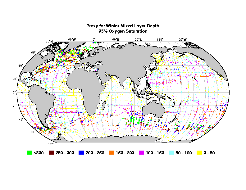
Proxy for winter mixed layer depth - depth of the 95% oxygen saturation (Figure) (From Talley, 1999 with update in Hanawa and Talley, 2001.)
SAMW temperature and thickness (McCartney, 1977)
Other mode waters. One other subtropical mode water deserves general mention. These are found in the poleward, eastern corner of each subtropical gyre. They are relatively light - lower density and higher temperature than the STMWs. They appear to be formed through subduction of the northeastern most water of the subtropical gyre. These waters are relatively thick because they are associated with the south side of a front that bends equatorward in each gyre.
Central Water and Subtropical Underwater. "Central water" refers to all of the waters in the main pycnocline that separates the upper ocean from the abyssal ocean. This "water mass" thus has a wide range of temperatures and salinities, as they vary strongly and continuously through the pycnocline. The reason this pycnocline receives a water mass name is a little obscure, but it dates back to at least Sverdrup. Using our flexible definition of a water mass, naming this as a water mass is quite reasonable, since the varying theta/S relation through the pycnocline is a consequence of subduction from different parts of the subtropical gyre. The circulations from these different parts overlay each other vertically, which allows waters from different parts of the sea surface to end up stacked vertically.
The subduction process occurs along isopycnals. Also possibly active in the pycnocline is diffusion (mixing) across isopycnals that mixes out bumps in the theta/S relation. Much attention has been paid to this process as a means of maintaining the pycnocline, excluding the subduction process. The truth is likely a combination of both processes, but with subduction the more important process.
In the North Pacific, indications of subduction and creation of Central Water can be seen through property distributions on isopycnal surfaces, and through creation of vertical extrema in salinity. A shallow salinity minimum in the eastern part of the subtropical gyre is created where the northernmost, freshest water of the subtropical gyre subducts beneath the saltier (warmer and less dense) water farther south. Tongues of tritium along isopycnals are also indicators of subduction. Tritium enters the ocean from the atmosphere and at a higher rate in more northern latitudes.
The surface waters of the central subtropical gyre are very salty as a result of evaporation under the atmospheric high pressure region. On the southern side of the N. Pacific subtropical gyre, subduction (sliding down and southward advection) of high salinity surface water from the evaporation center of the gyre creates a shallow salinity maximum in the vertical. The waters above the maximum are fresher since they are more tropical, where there is more rain. The waters below the maximum are fresher since they are from higher latitudes, where there is also more precipitation and less evaporation. This shallow salinity maximum is sometimes referred to as Subtropical Underwater.
Figure. Salinity at 150W in the upper Pacific showing underwater
In the North Atlantic, as in the North Pacific, subduction in the Ekman convergence region moves water from the sea surface southward into subsurface layers of the subtropical gyre. Central Water is the general name for the whole of the thermocline. As mentioned in a previous topic, Iselin (1939) proposed that the subtropical thermocline properties are set by this subduction process, which was further elaborated by Stommel and then received its name and formal theory from Luyten, Pedlosky and Stommel (1983). Also as mentioned before, vertical mixing between warm surface water and cold deep water is considered the other explanation for the thermocline; both subduction (along isopycnals) and mixing (across isopycnals) likely are operative.
Subduction throughout the subtropical gyre is evidenced in salinity (and tritium) along isopycnals that outcrop in the subtropical gyre (Sarmiento figures). Somewhat thick near-surface layers in the northeastern subtropical gyre also subduct southward (temperatures around 11-12C) (cartoon from McCartney, 1982 including wind stress curl pattern).
Subtropical Underwater is clearly apparent on the equatorward side of the subtropical gyres.
Figure. Salinity at 25W in the upper Atlantic showing underwater in both the North and South Atlantic.
Indonesian throughflow. Upper ocean water leaves the North Pacific in the tropics and flows westward through the Indonesian archipelago into the Indian Ocean. Thus relatively fresh, warm water from the Pacific is carried into to Indian Ocean. This flow of about 10 Sv is important to global heat and freshwater budgets, and is included in all concepts of the global overturning circulation. The fresh layer extends down to about 1000 meters, which is the sill depth of the Indonesian passages.
Figure. Salinity at 90E in the upper Indian showing underwater and the fresh throughflow water