 Fall, 2019
Link to presentations
Download pdf I (rotation, Coriolis, centrifugal forces)
Reading
Rotation (centrifugal and coriolis):
DPO section 7.2.3 or S7.2.3
Inertial motion:
DPO section 7.5.1 or S7.5.1
Geostrophy and dynamic height (second lecture):
DPO section 7.6.1 to 7.6.3 or S7.6.1 to S7.6.3
For hands-on Coriolis effect lesson, including cutout to demonstrate for yourself: American Meteorological Society peer education: Coriolis
1. What do inertial oscillations look like at 45S? What is their period?
2. Work out the period of inertial oscillations at the north pole, 30N, equator, and south pole.
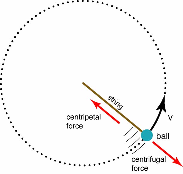
3. Justify the fact that we almost never talk about centrifugal force, although it is pretty large. Would it be correct to use a single number for gravity if you were trying to be really accurate about forces? What would be the most basic (latitudinal) correction to gravity that you would need to make?
4. Think HARD about how Coriolis works at the north pole - can you picture the reason for the rightward turn? Now think about it at the south pole.
5. Think HARDER about how it works at say 45N.
6. Finally, think REALLY hard about how the Coriolis works for motions that go east-west on the surface of the earth (consider 45N).
7. In geostrophic flow, what direction is the Coriolis force in relation to the pressure gradient force? What direction is it in relation to the velocity?
8. What are the common methods for measuring currents in the ocean?
9. Why do we use a method based on temperature and salinity instead of direct current measurements for most of the ocean?
10. How are temperature and salinity information used to calculate currents? What is the biggest drawback to this method?
11. What is a "level of no motion"? Why would a "level of known motion" be a better choice for the same kind of calculation? (What can we actually compute about the velocity structure given the density distribution and an assumption of geostrophy?)
12. If you already somehow know that the sea surface across the Gulf Stream is 1 meter higher on the east side than on the west, and that its isopycnals slope downward towards the east, recast the argument for how the PGF varies with depth, starting at the sea surface and working downwards.
13. The southern hemisphere also has strong boundary currents, like the Gulf Stream and Kuroshio. Off the eastern coast of Africa for instance is the Agulhas Current. The Agulhas Current flows along the coast from north to south (opposite direction to the Gulf Stream). What is the relative pressure onshore and offshore? What do the isopycnals look like in the Agulhas assuming it has the exact same vertical structure as the Gulf Stream (i.e. decreasing velocity with increasing depth)
2. What is the volume transport in m3 /sec of a current with velocity 10 cm/sec over a width of 200 km and a depth of 5000m?
3. What dynamic height difference over a width of 100 km is associated with a current speed of 100 cm/sec?