Reading, references and study questions - click here
Link to powerpoint presentation from class.
These notes includes water mass descriptions and a summary of global circulation in addition to the material on the wind-driven gyres and Antarctic Circumpolar Current that are the subject of the lecture.
The subpolar circulation is not quite the closed cyclonic circulation of the North Pacific, because the northeastern boundary (between Greenland and the United Kingdom) is partially open, unlike the Gulf of Alaska. Part of the subpolar flow proceeds on north into the Norwegian Sea - this component is essentially part of the thermohaline circulation, discussed below. Part of the subpolar circulation makes its way westward past Iceland (although not at the sea surface) and follows the deep boundaries to Greenland, around Greenland into the Labrador Sea and then southward out of the Labrador Sea. Western boundary currents are found along the eastern side of Greenland ("East Greenland Current") and along the Labrador coast ("Labrador Current"). The strong boundary currents around the rim of the subpolar gyre penetrate to great depth without much change in velocity, unlike the subtropical currents. The Subarctic Front extends northeastward from the North Atlantic Current, and passes east of Iceland into the Norwegian Sea.
Figures. Cartoon from Tomczak and Godfrey. Reid (1994) adjusted steric height at the sea surface, 500 dbar, 800 dbar, 3000 dbar, 4000 dbar. Worthington (1976) "two gyres" (Gulf Stream and North Atlantic Current as two western boundary currents for the subtropical gyre) with transports. Wind stress curl pattern showing relation of wind to the Gulf Stream and North Atlantic Current (McCartney, 1982).
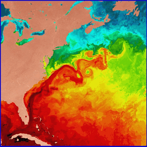
The Gulf Stream is an energetic, unstable flow. It meanders vigorously, with the meanders occasionally cutting off to form rings. Anticyclonic warm core rings are found north of the Gulf Stream and cyclonic cold core rings are found south of the Gulf Stream. The rings migrate westward and occasionally remerge with the Gulf Stream.
There isn't time in this single lecture to discuss the North Atlantic Current, but the connection of some of the transport in the Gulf Stream Extension (which is well separated from the coast) to the North Atlantic Current is required by mass considerations for the thermohaline circulation. Inshore of the North Atlantic Current there is southward flow (between Newfoundland and Flemish Cap) and north of the separated Gulf Stream there is westward flow along the continental slope (called the "Slope Water Current").
Figures in overheads. Gulf Stream and Kuroshio anatomies from Kawai (1972). Davis (1991) and Owens (1992) floats at surface, 700 m and 2000 m. Schmitz (1980) current meters at 55W. Showing penetration of Gulf Stream to bottom, meandering, deep recirculations (westward flow on either side of the eastward Gulf Stream).
SST in the western N. Atlantic.
Shown as a bright red band, the Gulf Stream is about 27C (~80F) in
this sea surface temperature image of the Western North Atlantic
during the first week of June 1984. This image is based on data from
NOAA-7 Advanced Very High Resolution Radiometer (AVHRR) infrared
observations, analyzed at the U. Miami Rosenstiel School's Remote
Sensing Laboratory. Warmer hues denote warmer temperatures.
Credit: O. Brown, R. Evans and M. Carle, University of Miami
Rosenstiel School of Marine and Atmospheric Science, Miami, Florida.
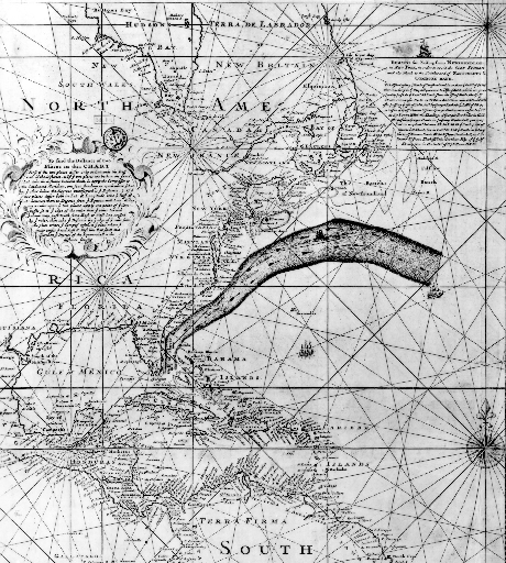
The Franklin-Folger map of the Gulf Stream, printed in 1769-1770. This early map of the Gulf Stream location was produced by B. Franklin for the mail service from England, based on information from whaling captain Timothy Folger. This map was rediscovered by P. Richardson (1980), and is remarkably accurate. This image is from R. Peterson et al. (1996), article in Progress in Oceanography.
North Atlantic Current - the second subtropical gyre WBC . The subtropical gyre in the N. Atlantic is more complicated than in the North Pacific because of the juxtaposition of the wind curl pattern and the shape of the western boundary. There are actually two subtropical western boundary currents. The Gulf Stream is the best known and was just described. The North Atlantic Current is the second, and is found east of Newfoundland. (further description will be included soon.)
Labrador Current and East Greenland Current . The cyclonic (anti-clockwise) subpolar gyre winds around several regions each presenting a western boundary that supports a western boundary current. The Labrador Current is the main western boundary current of the subpolar gyre, forming along the coast of Labrador. (more will be included in the notes)
The East Greenland Current is the western boundary current that forms off the east coast of Greenland, also as part of the subpolar gyre. It reaches the southern tip of Greenland where much of the water in the current continues around into the Labrador Sea, into the West Greenland Current. Since western boundary currents are more stable than eastern, there is a quasi-separation of the EGC at the southern end of Greenland. Part of the current separates and forms an eddy fields that propagates westward into the Labrador Sea. Part of it enters the WGC.
Generally one finds western boundary currents at every single western boundary. This is because of the dynamics that creates western boundary currents, with intensified currents in response to basin-wide (or even small-basin-scale) wind stress curl. (Sverdrup balance)
At the southern end of South America, the Antarctic Circumpolar Current (ACC) loops far to the north as a western boundary current called the Malvinas or Falkland Current. It then loops back southward nearly immediately offshore (called the "Falkland loop") and rejoins the ACC.
Salinity sections show the saline evaporation region of the subtropics at the sea surface. North-south property sections show the southward progress of the saline, high oxygen, low silica North Atlantic Deep Water between about 1500 and 3500 m. Above the NADW is the low salinity Antarctic Intermediate Water, whose origin is discussed below in the southern ocean paragraphs. It is flowing northward on average. Below the NADW is the Antarctic Bottom Water (also known as Lower Circumpolar Deep Water), whose origin is also discussed below, and which is also flowing northward on average.
Isopycnal plots show that the low salinity AAIW extends northward into the tropics along the western side of the South Atlantic. The saline NADW moves southward into the South Atlantic also along the western side. On the deepest isopycnals, water is only present west of the Mid-Atlantic Ridge - hence the Antarctic Bottom Water of the 25W vertical section is confined west of the ridge. The densest waters (the true bottom waters of the Weddell Sea) are confined to the far south, essentially south of the Antarctic Circumpolar Current.
The eastern boundary current of the Indian subtropics, the Leeuwin Current, is an anomaly compared with other oceans - it flows poleward. It is connected to waters that flow westward through the Indonesian archipelago from the Pacific Ocean, although most of the water that comes through the Indonesian passages flows directly westward along about 10S towards the western boundary. This can be seen as lower salinity in the section shown below. The Leeuwin Current and the northern Indian Ocean circulation will be discussed in the eastern boundary current and monsoon lecture (topic 7).
Abyssal flow in the Indian Ocean is northward from the Antarctic since no bottom water is formed in the Indian Ocean. A deep water is formed in the Red Sea, similar to Mediterranean Water, but affecting a deeper layer since there is no denser northern source of water. The bottom topography of the Indian Ocean is very complicated, leading to a fractured abyssal circulation with deep western boundary currents along each of the ridges.
North-south sections of properties show the high salinity evaporation region of the subtropical gyre (with its equatorward subsurface salinity maximum, the Subtropical Underwater). Below the saline surface layer is the salinity minimum of the Antarctic Intermediate Water (AAIW). In the south Indian Ocean, the salinity maximum below the AAIW extends northward from the Antarctic Circumpolar Current. Much of the high salinity of this layer comes from its source in the North Atlantic (remnant of North Atlantic Deep Water). At the bottom is the fresher Antarctic Bottom Water or Lower Circumpolar Deep Water. In the north Indian Ocean, the deep-reaching saline water originates in the Red Sea, which is an area of high evaporation. The near-surface high salinity water is from the Arabian Sea as well as the Red Sea and Persian Gulf. On the section that I am showing, which is in the central Indian Ocean, there is a very thin layer of low salinity water at the sea surface in the north, which originates in the Bay of Bengal and results from major river runoff into this area, including the Ganges and many other large rivers.
There is a subsurface oxygen maximum that is somewhat shallower than the Antarctic Intermediate Water. This can be traced back to the sea surface south of Australia where winter mixed layers are very deep. This water mass is called Southeast Indian Subantarctic Mode Water, and is a special, voluminous type of the more general water mass described below.
Indonesian throughflow. Upper ocean water leaves the North Pacific in the tropics and flows westward through the Indonesian archipelago into the Indian Ocean. Thus relatively fresh, warm water from the Pacific is carried into to Indian Ocean. This flow of about 10 Sv is important to global heat and freshwater budgets, and is included in all concepts of the global overturning circulation.
The abyssal flow of the South Pacific consists of northward flow from the Antarctic, entering mainly in the west as shown by deep silica distributions, and flowing northward through Samoan Passage to the tropics and then up along the western side of the North Pacific.
Salinity sections show the evaporation region at the sea surface in the subtropical gyre with an equatorward-extending salinity maximum just below the sea surface, the Subtropical Underwater. There is a Subtropical Mode Water associated with the northern side of the East Australia Current. Below the surface high salinity layer is a salinity minimum layer, the Antarctic Intermediate Water. In the tropics it is somewhat difficult to distinguish in this vertical section from the North Pacific Intermediate Water that extends southward, but consideration of basin-wide properties allows the boundaries to be drawn (see below). The abyssal Pacific is higher salinity, with the highest salinity in the south in the Antarctic Circumpolar Current. The reduction of salinity towards the north indicates that there must be diapycnal mixing of fresh water downwards since there is no source of deep water in the North Pacific.
Oxygen sections show high oxygen in the AAIW layer and in the abyssal layer, with low oxygen extending southward from the North Pacific. This low oxygen (high silica) layer is the Pacific Deep Water, returning southward after being formed from upwelled abyssal water (and possibly downwelled intermediate water).
Subpolar (cyclonic) circulations are found south of the ACC, most particularly in the Weddell and Ross Seas, both of which have western boundary currents that can support a wind-driven cyclonic gyre.
Subantarctic Mode Water (SAMW) is the name given to the very thick mixed layers north of the Subantarctic Front. These mixed layers are thickest in the eastern Indian and across the Pacific sectors of the ACC. Their temperatures decline from 14C in the western South Atlantic (just north of the SAF which is also just east of the Falkland Loop) to 4C in the eastern South Pacific, just west of Chile where the ACC enters Drake Passage. Part of the SAMW of the southeast Indian Ocean circulates northward into the Indian Ocean subtropical gyre and is the source of the oxygen maximum layer throughout the Indian Ocean. Part of the SAMW of the southeast Pacific circulates northward into the Pacific Ocean subtropical gyre and is the source of the low salinity Antarctic Intermediate Water there. Part of the latter (SE Pacific) SAMW flows eastward through Drake Passage and is the source of the low salinity AAIW for the combined Atlantic and Indian subtropical regions.
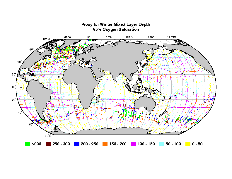
Proxy for winter mixed layer depth - depth of the 95% oxygen saturation (Figure) (From Talley, 1999 with update in Hanawa and Talley, 2001.)
NADW (deep water of the circumpolar current) upwells south of the ACC and is the source water for dense water formation around the Antarctic continent. The dense water formation occurs mainly as a result of ice formation (brine rejection) on the shelves. The primary sites for this are in the Weddell and Ross Seas, although there are also shelf water sources in the region south of Australia. The cold, dense shelf water flows down the shelves, mixing, and then out towards the east. Its pathways are strongly affected by bottom topography.
The wind-driven circulations of each subtropical region include an poleward western boundary current and anticyclonic circulation. Just offshore and equatorward of the separated western boundary currents is found the relatively thick layer that we have called Subtropical Mode Water, shown in red in the figure, with schematic cyclonic streamlines to indicate the subtropical gyre. These are around 16 to 19C in each ocean. The pink regions in the figure indicate a lower density subtropical mode water of the poleward/eastern portions of the subtropical gyres. This was not discussed in the lectures, and is mentioned only here for completeness. These eastern STMWs are subducted into the subtropical circulations. Not shown in the figure is the location of the Subtropical Underwaters of each subtropical ocean (should be added to the figure).
The other mode waters discussed in class and shown in the figure are the Subpolar Mode Water of the North Atlantic's subpolar gyre (thick mixed layers evident in the previous winter mixed layer map) and the Subantarctic Mode Water (the thickest part shown as the brown patch in the mode water map).
Location of warm, upper ocean mode waters (Figure), including the Subtropical Mode Waters (around 18C) of each subtropical gyre (red). Lower density subtropical type mode waters of the eastern region of each subtropical gyre (not included in class discussion) (pink). Subpolar Mode Water of the North Atlantic, Subantarctic Mode Water north of the Subantarctic Front (only the region of deepest mixed layers is shown), North Pacific Central Mode Water (not discussed in class - Suga et al., 1997) (brown). Schematics of the gyre circulations are indicated as well, but are clearly just cartoons. (From Talley, 1999 with update in Hanawa and Talley, 2001.)
The intermediate waters of the world ocean are usually traced by their salinity extrema. The two salinity maximum intermediate waters are formed in marginal seas in the high evaporation zone of the subtropics. These are the Mediterranean and Red Sea Waters, the former entering the North Atlantic at mid-depth and the latter filling the northern Indian Ocean (neither shown in the figure). The three low salinity intermediate water masses are formed at high subtropical or subpolar latitudes from surface water that has relatively low salinity. The three intermediate waters have different formation processes (in the regions marked by X in the figure). North Pacific Intermediate Water is formed from shelf water in the Okhotsk Sea, densified by brine rejection, mixed with North Pacific water in the Kuril Straits and including the low salinity surface waters of the Oyashio. It is a salinity minimum only in the North Pacific's subtropical gyre, but ventilates the entire subpolar region as well, where it does not have a salinity extremum. Labrador Sea Water forms through open ocean convection in the western Labrador Sea, from relatively fresh surface water. Since it sinks to mid-depth, below the inflowing more saline surface waters of the subpolar gyre, it appears as a salinity minimum throughout the subpolar gyre. Its influence is traced southward along the western boundary into the subtropical gyre and on into the tropical Atlantic through its relatively large thickness (resulting from its convective source) and through high oxygen. Antarctic Intermediate Water is a high latitude subtropical water mass, formed as the densest of the thick Subantarctic Mode Waters where the Antarctic Circumpolar Current is farthest south, just west of Chile. The SAMWs are located just north of the ACC and hence are in the subtropical gyres of the southern hemisphere. AAIW is subducted northward into the South Pacific's subtropical gyre. Part of the AAIW flows eastward through Drake Passage and enters the combined South Atlantic and Indian subtropical gyre through mixing in the Falkland (Malvinas) Loop.
Location of the three major salinity minimum intermediate waters (Figure). The X's mark the primary formation regions for each to the water masses. North Atlantic - Labrador Sea Water (extent of the potential vorticity minimum). North Pacific - North Pacific Intermediate Water (extent of salinity minimum in subtropical gyre, and indication that the ventilated water also completely covers the subpolar gyre, although NPIW is not a salinity minimum there since the surface waters are even fresher). Southern hemisphere - Antarctic Intermediate Water (extent of salinity minimum; extension of high silica northward in the subpolar North Atlantic is not indicated). Hatching indicates regions where mixing is critical to formation and modification. Clearly mixing occurs elsewhere as well, but these special areas set the properties for much larger regions. (From Talley, 1999.)The global influence of North Atlantic Deep Water is shown by salinity on a global isopycnal (Reid and Lynn, 1976) - showing high salinity originating in the North Atlantic and spreading southward and then eastward around Antarctica and entering the Indian and Pacific Oceans.
The influence of Antarctic Bottom Waters is illustrated with the location of a deep isopycnal (next figure), which is the lowest density water of Antarctic origin that is clearly separated from the Nordic Seas Overflow Waters (in the western North Atlantic). All higher densities south of the northern North Atlantic of course have significant Antarctic influence. At somewhat lower densities, one must more carefully differentiate between the Nordic Seas and Antarctic influences.
Location of isopycnal sigma_4 = 45.92 (Figure). (From Talley, 1999.)Bottom properties from Mantyla and Reid show the northward penetration of the cold Antarctic waters, into the western South Atlantic, the eastern Indian and the western South Pacific. The coldest waters remain confined to the Antarctic. Bottom silica shows how globally the North Atlantic has the lowest silica (since it is the best ventilated of the oceans), and the northern Indian and northern North Pacific have the highest silica (oldest bottom waters).
Returning to one of the global overturning diagrams from Schmitz, we now look more carefully at the Antarctic sources as well as the North Atlantic sources of deepest waters. We divide the oceans again into four layers - thermocline, intermediate waters, deep waters and bottom waters.
The net meridional directions of water mass transports in each ocean are demonstrated with figures from papers showing net transport as a function of either depth of density. In the North Pacific (Roemmich and McCallister, 1989) we see the shallow overturning subtropical gyre in the upper ocean (northward Ekman transport balanced by southward gyre transport), and inflow at the bottom, returning southward at a level just above the bottom. In the South Pacific (Wunsch et al., 1983) the subtropical gyres are not clearly demonstrated. The AAIW (indicated as Circumpolar Intermediate Water) is shown moving northward. Northward inflow occurs at the bottom, and the thick Pacific Deep Water moves back to the south. In the North Atlantic (Roemmich and Wunsch, 1985), we again don't see the subtropical gyre well, but see northward flow of upper ocean waters, northward flow of Antarctic Bottom Water, and southward flow of North Atlantic Deep Water. In the South Atlantic (Rintoul, 1991), we see northward flow of AAIW and Upper Circumpolar Water, northward flow at the bottom (Antarctic Bottom Water, or Lower Circumpolar Water), and southward flow of the North Atlantic Deep Water. In the south Indian Ocean (Toole and Warren, 1993), we see northward flow of Circumpolar Water and North Atlantic Deep Water, and southward flow of thermocline water.
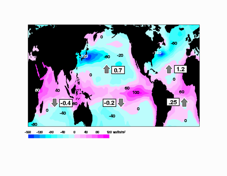
The total heat transports associated with these mass transports
are shown on a map of net surface heat flux
Superimposed on the figure are arrows and magnitudes (PW) of meridional ocean
heat transport from Roemmich and Wunsch (1985, N. Atlantic),
Rintoul (1991 - S. Atlantic), Robbins and Toole (1997- Indian),
Roemmich and McCallister (1991 - N. Pacific), Wunsch et al. (1983 -
S. Pacific). We note the northward direction of heat transport
in the South Atlantic, in contrast with poleward heat transport
in all other basins, due to location of northern
hemisphere overturning (North Atlantic only, not North Pacific).
Net surface heat flux (W/m^2) from
Hsiung, 1985
with net heat transports superimposed based on quoted
references, from Talley, 1999.
The data were described in previous lectures.
along a meridional section at approximately 150W.
Data were collected in 1984 (north of Hawaii), and in 1991 between 38S and Hawaii, and in 1992 south of 38S. The 1991 and 1992 portions were collected as part of WOCE. A reference for the 1984 portion is:
Talley, L.D., T.M. Joyce and R. A. deSzoeke, 1991. Transpacific sections at 47N and 152W: distribution of properties. Deep-Sea Res., 38 (Suppl), S63-S82.
The data were collected in 1994-1995 as part of WOCE.