The next set of lectures concerns circulation and water property distributions in each of the oceans. We use a combination of dynamic topographies and water property maps and vertical sections to say what the circulation is and where the waters are ventilated. A number of figures were already presented in the previous lectures, showing meridional vertical sections and vertical profiles of temperature and salinity. Also shown previously were the wind forcing fields, surface temperature and surface salinity.
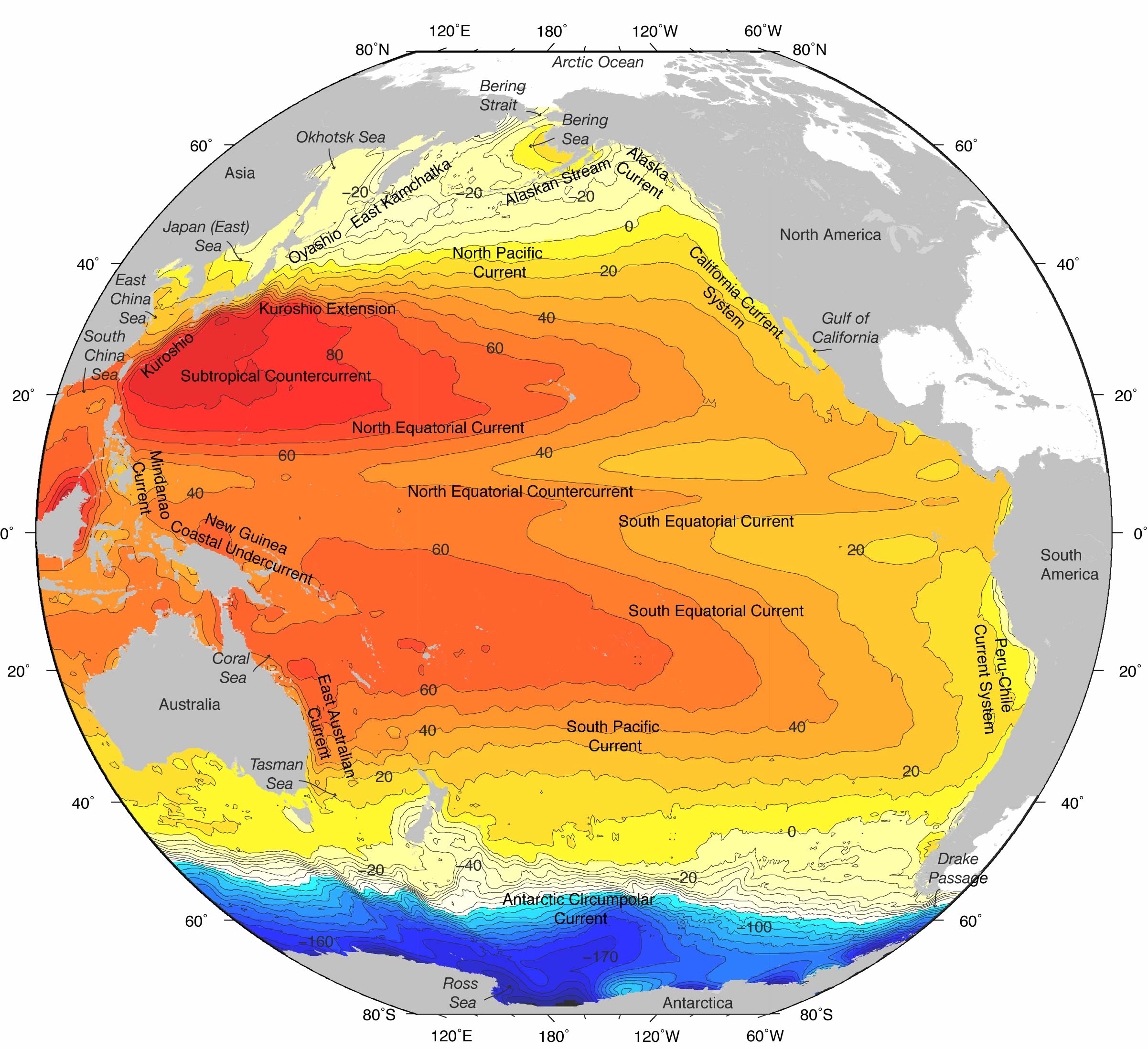
We begin with the North Pacific because it has the simplest thermohaline forcing of any of the ocean basins and is thus the best basin to first grasp principles of wind-driven circulation. While there is thermohaline forcing in all oceans, and undoubtedly upwelling as a result of the global thermohaline forcing, there are no deep water sources in the North Pacific and the intermediate water sources are weak. Thus the N. Pacific is actively ventilated to no more than 2000 meters depth, which coincides with the depth of the wind-driven circulation. Circulation below this must be thermohaline, but most of the forcing is due to remote deep water formation in the southern ocean and Atlantic. Weak geothermal forcing in the deep North Pacific might also have an effect on the deep circulation. Strong ventilation due to surface outcrops in the open North Pacific affects only the top 1000 meters, and is directly tied to the wind-driven circulation.
At 1000 meters depth, the subtropical gyre differs clearly from the surface gyre - while its northern and western sides appear in the same location as at the surface, its southern boundary is considerably farther north than at the surface, and its eastern portion is weak or non-existent. This poleward shrinkage of the subtropical gyre was first documented by Reid and Arthur and is a feature of the subtropical gyre in every ocean basin.
Vertical changes in the subpolar and tropical cyclonic gyres are not as apparent as in the subtropical gyre, probably because of the very narrow meridional extent of both gyres. The subpolar gyre would extend much farther north but for the presence of Alaska; its extension into the Bering Sea is considerably complicated by the Aleutian Arc. In dynamic topographies, it appears to have little variation in shape with depth although its existence below about 2000 meters is doubtful. The tropical gyre is also very narrow due to the wind pattern which causes it, and its vertical penetration is also not clear.
The westward flow of the southern subtropical gyre and northern tropical gyre is referred to as the North Equatorial Current. The NEC appears to be more intense in the tropical circulation than in the subtropical circulation. The eastward flow on the south side of the tropical gyre is the North Equatorial Countercurrent; despite its narrowness it is very swift and carries a large transport. The equatorial currents are described in a later lecture.
After passing through Tokara Strait, the Kuroshio continues eastward and passes through the Izu Ridge just south of Japan. Between Tokara Strait and the Izu Ridge, the Kuroshio exists in one of two modes - it either flows due eastward or undergoes a large southward meander. This bimodality appears to be due to the wave-guide nature of the two bounding ridges. When the Kuroshio is in the large meander state, its transport is usually reduced compared to when it follows the "straight" (progressive meandering) path.
The Kuroshio separates from the land at the southeastern corner of Honshu (south of the Boso Peninsula). At this location the Kuroshio often undergoes a large northward meander, which often produces a warm core ring.
In the relatively shallow regions where it is a true western boundary current, the Kuroshio extends to the bottom. On either side of the northward flow it has narrow southward recirculations. Once the Kuroshio crosses the Izu Ridge and enters deep water, its dynamic signature appears to extend to the ocean bottom. Thus the mean currents measured at great depth at 155E show flow below the Kuroshio axis which is eastward relative to stronger recirculation regions to the north and south. However, the actual mean flow along the Kuroshio axis at great depth is weakly westward; one might think of this as a superposition of deep westward flow, perhaps driven through thermohaline forcing, on the deep Kuroshio, which derives its energy from the winds.
East Kamchatka Current/Oyashio. The East Kamchatka Current arises in the Bering Sea and flows along Kamchatka into the open North Pacific. A portion of the flow enters the Okhotsk Sea (around 5 Sv) where it is greatly transformed in properties and emerges with different T/S/O2 characteristics. The Okhotsk current emerges primarily at Bussol' Strait where it joins the EKC. South of this point the western boundary current is referred to as the Oyashio. It flows southward along the remaining Kuril Islands, along the coast of Hokkaido and separates at the southern end of Hokkaido. This location is about 500 km north of the Kuroshio separation point, and coincides more with the N. Pacific zero of Sverdrup transport, than with the zero of wind stress curl (which coincides fairly well with the Kuroshio separation point). East of its separation, the Oyashio can be thought of as continuing as a partially density-compensated front called the Subarctic Front, although the continuity of the Oyashio/ Subarctic Front is somewhat questionable.
The subarctic circulation appears to be composed of four nearly separate cyclonic cells: one in the Gulf of Alaska, one in the western subarctic region, and one in each of the Bering and Okhotsk Seas. Each of these has a western boundary current of sorts - in the Gulf of Alaska it is the Alaskan Stream, which appears to be mainly a northern boundary current except that the coastline has enough slant that it acquires western boundary current identity. This strong current evaporates at the southernmost point of the Aleutians, with some flow turning northward into the Bering Sea, some turning back eastwards. The western boundary currents of the Bering Sea and western subarctic gyres have been referred to already. In the Okhotsk Sea there also occurs a western boundary current - the East Sakhalin Current.
The principal eastern boundary current of the North Pacific is the California Current. It arises from a bifurcation of the North Pacific Current (west wind drift). A portion of the North Pacific Current water turns southward into the California Current and and portion northward as the eastern limb of the subpolar gyre. The exact location of the bifurcation, and hence the amount of water which flows northward versus southward, is time dependent. Since the northern waters have high nutrient content, the amount which enters the California Current could impact its local productivity.
Subduction is an isopycnal process (flow along isopycnals). It is manifested in the distributions of many tracers along isopycnals which outcrop in the subtropical gyre. In the North Pacific, a shallow salinity minimum in the eastern part of the subtropical gyre is created as the northernmost, freshest water of the subtropical gyre subducts beneath the saltier (warmer and less dense) water farther south. Tongues of tritium which is input from the sea surface, and at a higher rate in more northern latitudes are also indicators of subduction.
The density range of subducting waters extends to the maximum density which outcrops in the subtropical gyre, that is, along its northern boundary with the subpolar gyre. In the North Pacific, this maximum subducting density is around 26.2 sigma theta.
There are two quite different ideas for maintenance of the the main thermocline lying below the surface layer. The first is that its properties are mainly set by this subduction process, which occurs along isopycnals. The second is that the thermocline properties and vertical temperature/salinity/density profile are set by a vertical process (across isopycnals) - through mixing. The truth is likely a combination of both processes.
The "water masses" which are created by subduction are the Central Water (water in the thermocline, spread along a continuous temperature/salinity range), and Subtropical Underwater (salinity maximum arising from subduction of the very high central subtropical gyre waters beneath the fresher waters which lie to the south).
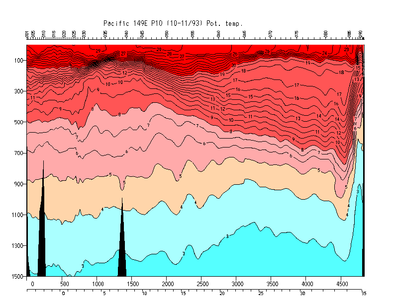
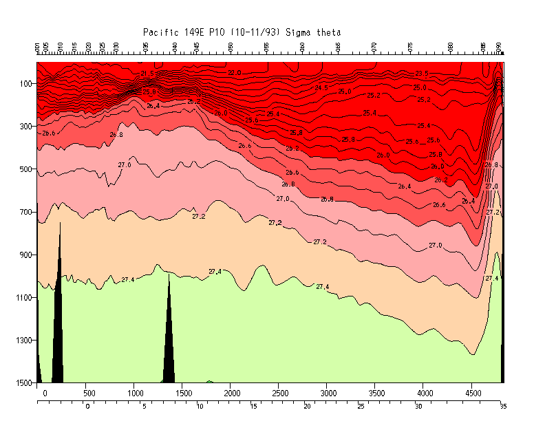
Subtropical mode water. In the western subtropical North Pacific, the main thermocline (pycnocline) is interrupted by a "thermostad" (pycnostad), which is a region of lower vertical gradients of temperature, salinity and density, compared with the thermocline above and below. Such a thermostad is typical of the major subtropical western boundary current recirculation regions in each ocean. This pycnostad in the North Pacific is referred to as "Subtropical Mode Water". "Mode" means relatively larger large volume on a volumetric T-S diagram (illustrate).
The STMW in the North Pacific is in the temperature range of 16-19C and is found just south of the Kuroshio Extension (Masuzawa, 1969). The temperature of the thick layer decreases eastward. This region is subject to two processes which could contribute to the thickness of the mode water: large winter heat loss due to the advection of warm water into the region combined with cold, dry air blowing off the continents, and the tilt of isopycnals in the Kuroshio Extension and recirculation which creates a "bowl" of warm water between the Kuroshio Extension and the recirculation. (The isopycnal tilting is of course associated with vertical shear of the horizontal geostrophic currents.)
Figure. Potential temperature at 149E (WOCE section P10) and Sigma theta at 149E (WOCE section P10) illustrating the North Pacific Subtropical Mode Water just south of the Kuroshio.
Sea ice formation in the Okhotsk ventilates the upper portion of the intermediate density layer of the North Pacific. Vertical mixing can be shown to be locally very important for extending the ventilated waters downward in the water column, especially along the Kuril Islands. The ventilated waters from the Okhotsk Sea exit through Bussol' Strait and join the remaining western boundary current waters of the East Kamchatka Current. The Okhotsk Sea ventilation is apparent in distributions of oxygen, chlorofluorocarbons, and tritium on isopycnals which clearly lie below the highest density found at the sea surface in winter in the open North Pacific. It is also apparent in the salinity distribution: since the water which is "formed" is very cold at its formation site, it is also the freshest water on its isopycnal. This is true even though brine rejection is part of the formation process: the rejected brine enters the near surface waters, which are close to freezing, and increases their density through the addition of salt. Thus there is a downward salt flux which is reflected in the appearance of newly ventilated, cold, fresh water at a higher density than at the sea surface.
The ventilated waters of the western subpolar gyre enter the subtropical gyre mainly along the western boundary, probably as meanders and intrusions from the separating Oyashio. Because they are quite fresh, they appear as a salinity minimum in the subtropical gyre. The salinity minimum itself appears close to the top of the layer which enters from the subpolar gyre. It or the full intermediate layer are often called North Pacific Intermediate Water.
The surface layer of the eastern subpolar gyre is a thick warm layer which is advected counterclockwise around the Alaskan gyre. West of the dateline, in the western Subarctic Gyre, a temperature minimum layer is usually found in summer. The temperature minimum arises from cooling in the winter and is permitted by the relatively strong subpolar halocline (fresh at the surface, increasing salinity with depth). Associated with the T min layer is very high oxygen saturation in the summertime, due to capping by surface warm water and slight warming of the subsurface T min layer. In the Japanese literature the temperature minimum layer is referred to as the dichothermal layer. Below the T min naturally there must be a temperature maximum layer, referred to as the mesothermal layer in Japanese literature. The maximum temperature indicates that this water must have a substantial component which comes from either the east or the south since otherwise it would have acquired the low temperature of the surface layer. In the Okhotsk Sea, the temperature minimum layer is much thicker and much deeper, reflecting the deep ventilation that occurs there.
A well-developed oxygen minimum layer lies at about 1500 meters. This is clearly within the depth range of NPIW ventilation, albeit very weak ventilation. The oxygen minimum is intensified within the bowl of the subtropical/subpolar gyres.
There are indications of slight warming on the bottom of the North Pacific, due to gentle geothermal heating. A characteristic of the Pacific Deep Water is a vertical deep silica maximum, whose lateral origin is in the northeastern Pacific. It is separated from the bottom Antarctic Bottom Water (also known as Lower Circumpolar Water) by a so-called "benthic front" in the southern and western North Pacific. The densest water enters the North Pacific across the equator in the west, through Samoan Passage (S. Pacific). This water flows northward and splits in the western N. Pacific, with a portion flowing eastward south of Hawaii and a portion continuing northward, possibly through Wake Passage but in a generally broad flow.
Silica on a near-bottom isopycnal reveals two separate deep circulations, which appear to be anticyclonic rather than cyclonic; one concentrated north of the latitude of the Hawaiian Island and the other to the south. Densest water enters the northern North Pacific along the western boundary, primarily channelled by the deep trenches along the western and northern boundaries.
Carbon-14 dating of deep waters - Stuiver
The eastward flow on the poleward side of the gyre is called the South Pacific Current. The Subtropical Front runs east-west through the South Pacific Current. The eastern boundary current is the Peru Current, which also includes a full coastal upwelling eastern boundary current. Other nomenclature that is useful for the eastern boundary current is the "Peru-Chile Current System", akin to the California Current System.
The westward flow on the equatorward side of the subtropical gyre is the South Equatorial Current. It also contains westward flow on the equator and as far north as 3 to 5 N.
The subtropical gyre shrinks poleward and westward with depth as in other oceans. The eastern boundary current is the Peru Current.
Indonesian throughflow. Upper ocean water leaves the North Pacific in the tropics and flows westward through the Indonesian archipelago into the Indian Ocean. Thus relatively fresh, warm water from the Pacific is carried into to Indian Ocean. This flow of about 10 Sv is important to global heat and freshwater budgets, and is included in all concepts of the global overturning circulation.
The abyssal flow of the South Pacific consists of northward flow from the Antarctic, entering mainly in the west as shown by deep silica distributions, and flowing northward through Samoan Passage to the tropics and then up along the western side of the North Pacific.
Salinity sections show the evaporation region at the sea surface in the subtropical gyre with an equatorward-extending salinity maximum just below the sea surface, the Subtropical Underwater. There is a Subtropical Mode Water associated with the northern side of the East Australia Current. Below the surface high salinity layer is a salinity minimum layer, the Antarctic Intermediate Water. In the tropics it is somewhat difficult to distinguish in this vertical section from the North Pacific Intermediate Water that extends southward, but consideration of basin-wide properties allows the boundaries to be drawn (see below). The abyssal Pacific is higher salinity, with the highest salinity in the south in the Antarctic Circumpolar Current. The reduction of salinity towards the north indicates that there must be diapycnal mixing of fresh water downwards since there is no source of deep water in the North Pacific.
Oxygen sections show high oxygen in the AAIW layer and in the abyssal layer, with low oxygen extending southward from the North Pacific. This low oxygen (high silica) layer is the Pacific Deep Water, returning southward after being formed from upwelled abyssal water (and possibly downwelled intermediate water).
The classical explanation of these currents is that equatorward winds force Ekman flow offshore, which drives a shallow upwelling (order 200 meters deep) in a very narrow region adjacent to the coast (order 10 km). Winds along the eastern boundaries of all oceans are favorable to upwelling, probably as a result of topographic steering of the westerly winds as they reach land. The upwelling results in uplift of cooler, nutrient rich waters from just below the surface layer and hence higher productivity and cooler waters. (Both are clear in satellite images - AVHRR to look at infrared which is a measure of temperature, and Coastal Zone Color Scanner which indicates pigment concentration.)
The upwelling is accompanied by a rise in isopycnals towards the coast. This has an associated geostrophic flow which is equatorward. This equatorward flow is the intensified eastern boundary current, which we identify separately from the general equatorward flow of the eastern part of the subtropical gyre. The eastern boundary currents are shallow, meandering currents. The actual eastern boundary currents such as the California Current are narrow (< 100 km width), meandering and have speeds of 40 to 80 cm/sec. They are located at the upwelling front created by the offshore Ekman transport. They have strong seasonality, described below.
The equatorward surface flow creates in some sense a piling of water towards the equator and hence a pressure gradient force which is northward. This drives a poleward current at the coast and usually just beneath the equatorward eastern boundary current (at ~200 meters). When upwelling favorable winds weaken or disappear, the equatorward flow also disappears and the poleward undercurrent is found to the surface.
Upwelling occurs over a broader region than just the very narrow coastal strip. This may be because the wind stress curl associated with the topographically steered winds is positive, creating a broader upwelling zone than would a strictly uniform wind with an equatorward component.
Offshore Ekman transport does not occur as a simple uniform offshore flux all along the eastern boundary. Rather it occurs in jets. Along California there are semi-permanent locations for the jets, apparently associated with the coastal geography - jets occurring at capes such as Point Arena.
Seasonality of the California Current has been fairly well described. In winter the California Current is weak or absent. As upwelling- favorable winds begin to blow, the current forms near the coast but quickly moves offshore. It is most strongly developed at the height of the upwelling season, in July-August. Surface dynamic height on the inshore side of the current varies seasonally by about 30 to 40 cm.
Productivity in the eastern boundary current regions is enhanced by both the local upwelling and by the advection of higher latitude waters, from broad upwelling regions (like the subarctic Pacific), towards the equator. Climate fluctuations can change the relative amount of higher latitude waters reaching the eastern boundary region.
The only ocean without an equatorward eastern boundary current is the Indian Ocean. The Leeuwin Current along the west coast of Australia flows poleward, even though the winds are upwelling favorable and would drive a normal eastern boundary current there in the absence of other forces. However, there is a much larger poleward pressure gradient force along this boundary than along the others, due to the flow of water westward through the Indonesian archipelago from the Pacific to the Indian Ocean.
The equatorward eastern boundary currents:
The poleward eastern boundary currents:
2. What drives the large gyres of the North Pacific? Describe the dynamic topography distribution that is associated with the gyres. Describe the vertical structure of the subtropical gyre. (What happens to its structure with depth?)
3. Where is the Kuroshio? Where does it become the Kuroshio Extension? How deep does the Kuroshio Extension reach? What is the circulation just to the south of the Kuroshio Extension? Does the Kuroshio Extension transport vary with longitude?
4. What is the direction of mean flow through Bering Strait? How deep is the strait?
5. What is the surface structure that separates waters of the subtropical and subpolar gyres? What is its importance for fisheries?
Water mass properties (not this lecture)
6. How does water get from the surface to below the surface
in the subtropical
gyre? (What is subduction?) Why is there a tongue of high tritium
and low salinity extending westward
along the southern limb of the subtropical gyre?
7. What is Subtropical Mode Water, where is it found, and what is a possible mechanism for forming it?
8. Where does the densest ventilation in the North Pacific occur? What processes are important in this ventilation? How is this relatively dense ventilation recognized on maps of oxygen and salinity?
9. What is the source of the deep water in the North Pacific?
10. What evidence is there for large-scale vertical mixing between the surface/intermediate/deep layers?
Eastern boundary currents
11. What direction must the wind blow for coastal upwelling to occur?
12. Why is the water off the California coast cold while that off of Florida is warm?
13. How are boundary currents on the eastern and western margins of the ocean different? What features do they have in common?
14. What causes large-scale upwelling along a coast? How deep does it reach? What sort of simple current does the wind create in theory? How does this differ from reality?
15. What is the usual overall structure of an eastern boundary current region, down to about 500 meters? What is interesting (somewhat unexpected) about the usual current structure just below the surface, at about 200 meters?
16. Name all of the eastern boundary currents of the subtropical gyres. What is different about the Leeuwin Current? Any reason why?
2. If the California Current velocity is 10 cm/sec over a depth of 200 m, with a width of 100 km, what is its approximate transport?
3. Calculate the approximate heat transport associated with the shallow part of the Kuroshio and its return flow. Assume that 50 Sv flows northward in the Kuroshio at 22C, and returns southward in the interior at 18C. Use a density of 1025 kg/m3 and a specific heat of 3850 J/(kg C).