Download pdf of presentation (second part of Atlantic-Indian upper ocean).
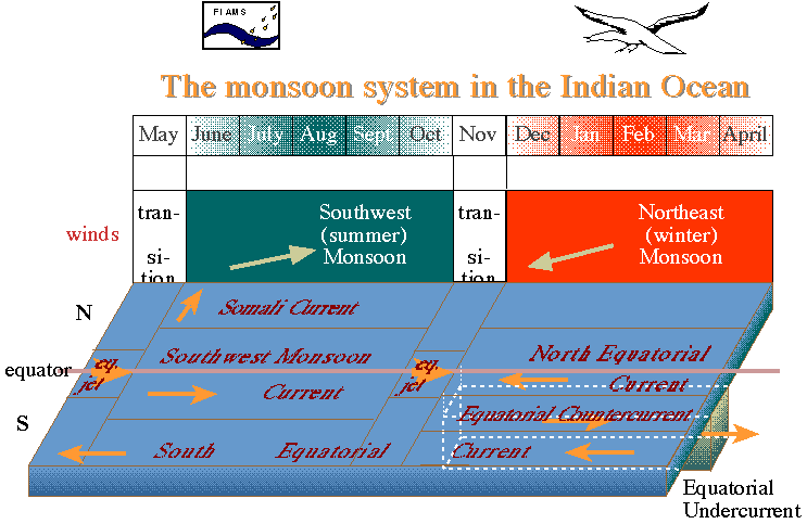
In summer, land is warmer than ocean so surface wind is from ocean to land. In winter, the reverse.
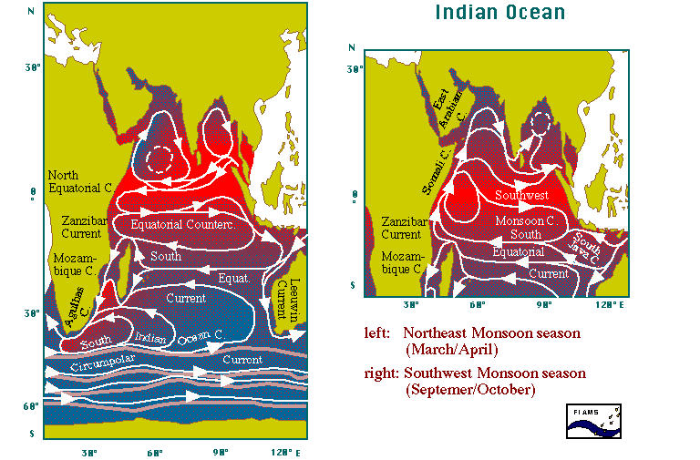
Indian (Asian-Australian) monsoon: late summer conditions are
strong air flow from
the Arabian Sea northeastward into India ("Southwest monsoon"),
accompanied by large precipitation over land.
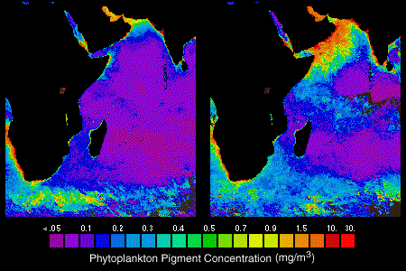
Wind along Arabia is especially intense ("Somali Jet" or "Findlater Jet"),
like an atmospheric western boundary current. The Somali
jet forces major upwelling along the Arabian coast (offshore
Ekman flow). Circulation in the Arabian Sea is anticyclonic
and the northward Somali Current (western boundary
current) is fully developed.
In autumn, the sea-air temperature contrast decreases. The Somali
jet
swings to the south and blows eastward ("Transition"). During the
Transition, a strong eastward surface jet develops in the
ocean along the equator. The Somali Jet weakens in these off seasons.
In winter, the wind blows from land to sea ("Northeast monsoon").
Upwelling in the Arabian Sea ceases.
Circulation in the Arabian Sea weakens and the Somali Current
can reverse.
Other monsoon regions: Asia up through China and Japan is part of the same monsoon system ("Asian-Australian monsoon"). The western part of Mexico up through Arizona experiences the "Pan-American monsoon". The southern hemisphere portion of this monsoon affects western South America in austral summer. The African monsoon system affects tropical Africa with major rainfall in the northern hemisphere in boreal summer and in the southern hemisphere in austral summer.
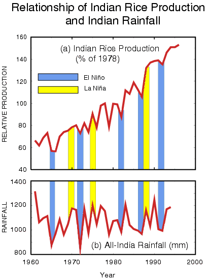
Figure. Indian rainfall and relationship to ENSO, from CLIVAR implementation plan: "Crop production vs. Indian monsoon rainfall. Notwithstanding the overall growth in rice production in India due to better farming practices and technological development, year-to-year fluctuations in production are determined largely by the success or failure of the summer monsoon which is in turn affected by the particular phase of the El Niño/Southern Oscillation phenomenon (from Webster et al. (1998), adapted from Gadgil, 1995)." (caption from CLIVAR implementation plan http://www.clivar.org/organization/aamp/publications/pg2.htm)
The eastern boundary current of the Indian subtropics, the Leeuwin Current, is an anomaly compared with other oceans - it flows poleward. It is connected to waters that flow westward through the Indonesian archipelago from the Pacific Ocean, although most of the water that comes through the Indonesian passages flows directly westward along about 10S towards the western boundary. This can be seen as lower salinity in the section shown below. The Leeuwin Current and the northern Indian Ocean circulation will be discussed in the eastern boundary current and monsoon lecture (topic 7).
Abyssal flow in the Indian Ocean is northward from the Antarctic since no bottom water is formed in the Indian Ocean. A deep water is formed in the Red Sea, similar to Mediterranean Water, but affecting a deeper layer since there is no denser northern source of water. The bottom topography of the Indian Ocean is very complicated, leading to a fractured abyssal circulation with deep western boundary currents along each of the ridges.
North-south sections of properties show the high salinity evaporation region of the subtropical gyre (with its equatorward subsurface salinity maximum, the Subtropical Underwater). Below the saline surface layer is the salinity minimum of the Antarctic Intermediate Water (AAIW). In the south Indian Ocean, the salinity maximum below the AAIW extends northward from the Antarctic Circumpolar Current. Much of the high salinity of this layer comes from its source in the North Atlantic (remnant of North Atlantic Deep Water). At the bottom is the fresher Antarctic Bottom Water or Lower Circumpolar Deep Water. In the north Indian Ocean, the deep-reaching saline water originates in the Red Sea, which is an area of high evaporation. The near-surface high salinity water is from the Arabian Sea as well as the Red Sea and Persian Gulf. On the section that I am showing, which is in the central Indian Ocean, there is a very thin layer of low salinity water at the sea surface in the north, which originates in the Bay of Bengal and results from major river runoff into this area, including the Ganges and many other large rivers.
There is a subsurface oxygen maximum that is somewhat shallower than the Antarctic Intermediate Water. This can be traced back to the sea surface south of Australia where winter mixed layers are very deep. This water mass is called Southeast Indian Subantarctic Mode Water, and is a special, voluminous type of the more general water mass described in the lecture on the southern ocean.
The data were collected in 1994-1995 as part of WOCE.
2. What is thermally direct circulation? What is the role of rotation in such a circulation? Is the surface pressure (atmospheric) high or low over the region of warmer temperature?
3. What causes upwelling in the Arabian Sea and during which monsoon does it occur?
4. During which part of the monsoon cycle is the tropical Indian Ocean circulation most like that of the Pacific and Atlantic?
5. What happens to surface currents along the equator during the transition between monsoons?
6. The Leeuwin Current is said to "go the wrong way". Contrast it with the eastern boundary currents in the other 4 oceans. Why does it go the "wrong" way?
7. Where does upper ocean water pass from the Indian to the Atlantic Ocean? What current does it start in in the Indian Ocean? What current does it possibly join in the Atlantic Ocean? List another mechanism besides smoothly-joined currents that passes water from the Indian to the Atlantic.
8. Where are the two locations where water passes between the Pacific and Indian Oceans?