Combined Atlantic and Indian upper ocean presentation
Download pdf
These are old notes, included here simply to avoid losing them. You might find them useful, but the primary source is the DPO 6th text. There are a few study questions also at the end of each part. They include both the Atlantic upper ocean, and Indian overall ocean circulation.
The subpolar circulation is not quite the closed cyclonic circulation of the North Pacific, because the northeastern boundary (between Greenland and the United Kingdom) is partially open, unlike the Gulf of Alaska. Part of the subpolar flow proceeds on north into the Norwegian Sea - this component is essentially part of the thermohaline circulation, discussed below. Part of the subpolar circulation makes its way westward past Iceland (although not at the sea surface) and follows the deep boundaries to Greenland, around Greenland into the Labrador Sea and then southward out of the Labrador Sea. Western boundary currents are found along the eastern side of Greenland ("East Greenland Current") and along the Labrador coast ("Labrador Current"). The strong boundary currents around the rim of the subpolar gyre penetrate to great depth without much change in velocity, unlike the subtropical currents. The Subarctic Front extends northeastward from the North Atlantic Current, and passes east of Iceland into the Norwegian Sea.
Figures. Cartoon from Tomczak and Godfrey. Reid (1994) adjusted steric height at the sea surface, 500 dbar, 800 dbar, 3000 dbar, 4000 dbar. Worthington (1976) "two gyres" (Gulf Stream and North Atlantic Current as two western boundary currents for the subtropical gyre) with transports. Wind stress curl pattern showing relation of wind to the Gulf Stream and North Atlantic Current (McCartney, 1982).
A marked westward flow exists south of the Gulf Stream ("Gulf Stream recirculation"). A westward flow usually carrying subpolar types of water is found north of the Gulf Stream ("Slope Water Current"). Together with the Gulf Stream, these form two "recirculation gyres", one to the south of the Gulf Stream, sometimes called the "Worthington gyre", and one to the north of the Gulf Stream, called the "northern recirculation gyre". Floats deployed at several depths and current meter arrays across the Gulf Stream show that the eastward flow penetrates to the ocean bottom. Near the ocean bottom there are narrow westward counterflows on either side of the Gulf Stream and so therefore the full surface structure of the Gulf Stream (strong eastward flow flanked by westward countercurrents) extends from top to bottom. This picture is much more striking than for the Kuroshio, whose structure is apparently similar to the ocean bottom, but upon which a weak westward deep flow appears to be superimposed.
The Gulf Stream is an energetic, unstable flow. It meanders vigorously, with the meanders occasionally cutting off to form rings. Anticyclonic warm core rings are found north of the Gulf Stream and cyclonic cold core rings are found south of the Gulf Stream. The rings migrate westward and occasionally remerge with the Gulf Stream.
There isn't time in this single lecture to discuss the North Atlantic Current, but the connection of some of the transport in the Gulf Stream (which is well separated from the coast) to the North Atlantic Current is required by mass considerations for the thermohaline circulation. Inshore of the North Atlantic Current there is southward flow (between Newfoundland and Flemish Cap) and north of the separated Gulf Stream there is westward flow along the continental slope (called the "Slope Water Current").
Figures in overheads. Gulf Stream and Kuroshio anatomies from Kawai (1972). Davis (1991) and Owens (1992) floats at surface, 700 m and 2000 m. Schmitz (1980) current meters at 55W. Showing penetration of Gulf Stream to bottom, meandering, deep recirculations (westward flow on either side of the eastward Gulf Stream).
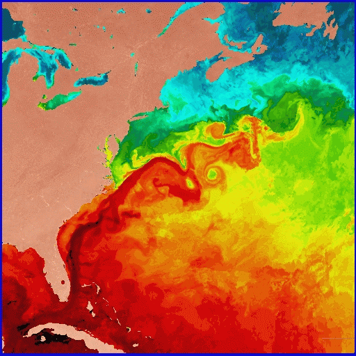
SST in the western N. Atlantic.
Shown as a bright red band, the Gulf Stream is about 27C (~80F) in
this sea surface temperature image of the Western North Atlantic
during the first week of June 1984. This image is based on data from
NOAA-7 Advanced Very High Resolution Radiometer (AVHRR) infrared
observations, analyzed at the U. Miami Rosenstiel School's Remote
Sensing Laboratory. Warmer hues denote warmer temperatures.
Credit: O. Brown, R. Evans and M. Carle, University of Miami
Rosenstiel School of Marine and Atmospheric Science, Miami, Florida.
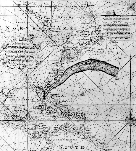
The Franklin-Folger map of the Gulf Stream, printed in 1769-1770. This early map of the Gulf Stream location was produced by B. Franklin for the mail service from England, based on information from whaling captain Timothy Folger. This map was rediscovered by P. Richardson (1980), and is remarkably accurate. This image is from R. Peterson et al. (1996), article in Progress in Oceanography.
North Atlantic Current - the second subtropical gyre WBC . The subtropical gyre in the N. Atlantic is more complicated than in the North Pacific because of the juxtaposition of the wind curl pattern and the shape of the western boundary. There are actually two subtropical western boundary currents. The Gulf Stream is the best known and was just described. The North Atlantic Current is the second, and is found east of Newfoundland. (further description will be included soon.)
Labrador Current and East Greenland Current . The cyclonic (anti-clockwise) subpolar gyre winds around several regions each presenting a western boundary that supports a western boundary current. The Labrador Current is the main western boundary current of the subpolar gyre, forming along the coast of Labrador. (more will be included in the notes)
The East Greenland Current is the western boundary current that forms off the east coast of Greenland, also as part of the subpolar gyre. It reaches the southern tip of Greenland where much of the water in the current continues around into the Labrador Sea, into the West Greenland Current. Since western boundary currents are more stable than eastern, there is a quasi-separation of the EGC at the southern end of Greenland. Part of the current separates and forms an eddy fields that propagates westward into the Labrador Sea. Part of it enters the WGC.
Generally one finds western boundary currents at every single western boundary. This is because of the dynamics that creates western boundary currents, with intensified currents in response to basin-wide (or even small-basin-scale) wind stress curl. (Sverdrup balance)
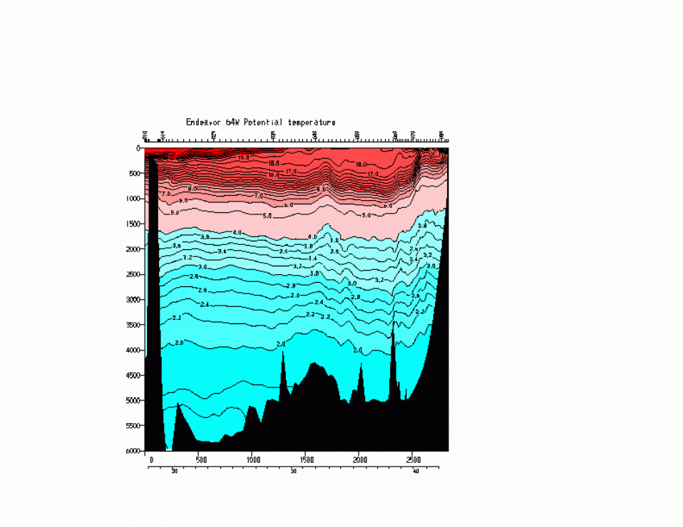
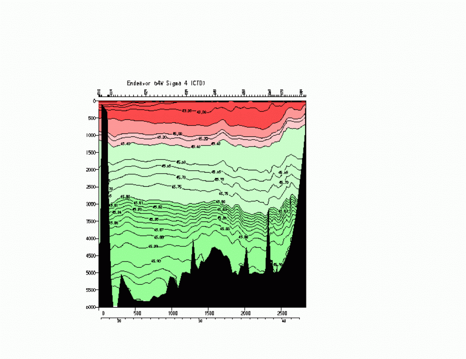
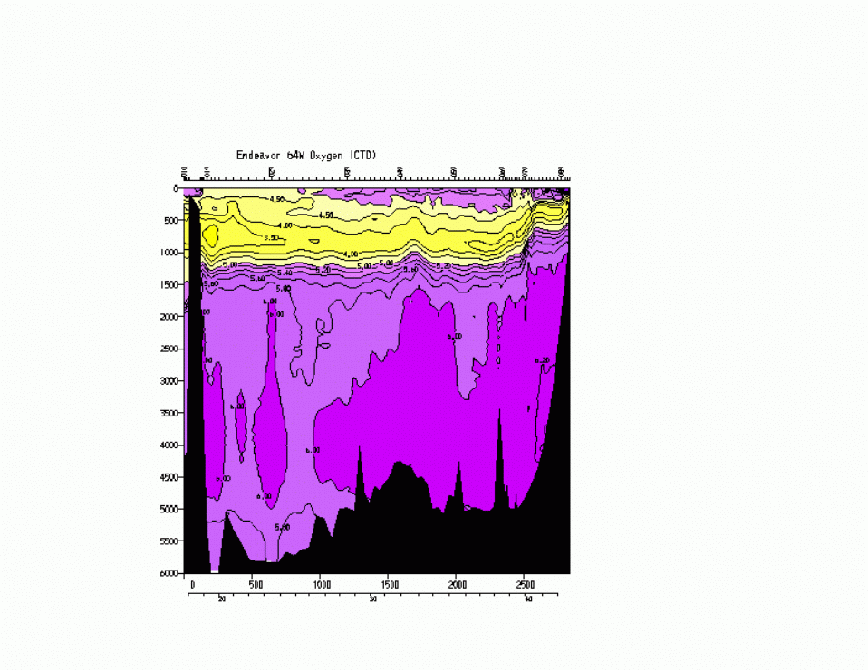
Potential temperature at 64W (crossing the Gulf Stream, showing 18
degree water).
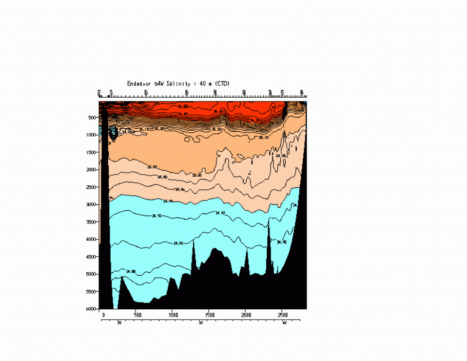
Salinity,
Potential Density (0 dbar),
Potential Density (4000 dbar)
Oxygen (ml/l)
Central Water and Subtropical Underwater. As in the North Pacific, subduction in the Ekman convergence region moves water from the sea surface southward into subsurface layers of the subtropical gyre. Central Water is the general name for the whole of the thermocline. As mentioned in topic 4, Iselin (1939) proposed that the subtropical thermocline properties are set by this subduction process, which was further elaborated by Stommel and then received its name and formal theory from Luyten, Pedlosky and Stommel (1983). Also as mentioned before, vertical mixing between warm surface water and cold deep water is considered the other explanation for the thermocline; both subduction (along isopycnals) and mixing (across isopycnals) likely are operative.
The surface waters of the central subtropical gyre are very salty as a result of evaporation under the atmospheric high pressure region. As this salty water subducts southward beneath water that is not quite as saline, it forms a salinity maximum in the vertical. This salinity maximum is typical of every subtropical gyre (we did not describe it for the North Pacific), and is sometimes called Subtropical Underwater.
Subduction throughout the subtropical gyre is evidenced in salinity (and tritium) along isopycnals that outcrop in the subtropical gyre (Sarmiento figures). Somewhat thick near-surface layers in the northeastern subtropical gyre also subduct southward (temperatures around 11-12C) (cartoon from McCartney, 1982 including wind stress curl pattern).
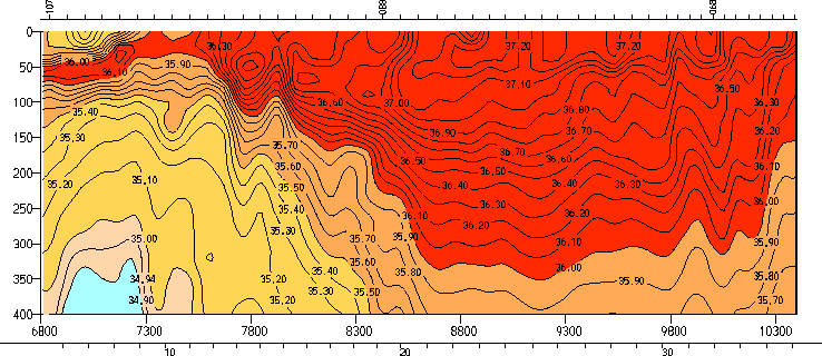
Salinity along 25W showing subducted high salinity
At the southern end of South America, the Antarctic Circumpolar Current (ACC) loops far to the north as a western boundary current called the Malvinas or Falkland Current. It then loops back southward nearly immediately offshore (called the "Falkland loop") and rejoins the ACC.
Salinity sections show the saline evaporation region of the subtropics at the sea surface. North-south property sections show the southward progress of the saline, high oxygen, low silica North Atlantic Deep Water between about 1500 and 3500 m. Above the NADW is the low salinity Antarctic Intermediate Water, whose origin is discussed below in the southern ocean paragraphs. It is flowing northward on average. Below the NADW is the Antarctic Bottom Water (also known as Lower Circumpolar Deep Water), whose origin is also discussed below, and which is also flowing northward on average.
Isopycnal plots show that the low salinity AAIW extends northward into the tropics along the western side of the South Atlantic. The saline NADW moves southward into the South Atlantic also along the western side. On the deepest isopycnals, water is only present west of the Mid-Atlantic Ridge - hence the Antarctic Bottom Water of the 25W vertical section is confined west of the ridge. The densest waters (the true bottom waters of the Weddell Sea) are confined to the far south, essentially south of the Antarctic Circumpolar Current.
2. Explain why the N. Atlantic's subtropical gyre has two different western boundary currents.
3. Explain why the N. Atlantic's subpolar gyre has two different western boundary currents.
4. Where is the Azores Current?
5. The subpolar gyre circulation is more complicated than the N. Pacific's subpolar gyre circulation. This gets into the next lecture on deep Atlantic water masses, but can you surmise why the surface currents of the N. Atlantic subpolar gyre flow to the northeast and up to the area west of Norway, while the deeper flow in the N. Atlantic subpolar gyre just follows along the bathymetry in a cyclonic pattern?
6. What regions of the North and South Atlantic are dominated by subduction? How might you figure out how deep the subduction reaches?
7. How does the equatorial current system differ from that in the Pacific?
8. What is Subtropical Underwater?
In summer, land is warmer than ocean so surface wind is from ocean to land. In winter, the reverse.
Indian (Asian-Australian) monsoon: late summer conditions are
strong air flow from
the Arabian Sea northeastward into India ("Southwest monsoon"),
accompanied by large precipitation over land.
Wind along Arabia is especially intense ("Somali Jet" or "Findlater Jet"),
like an atmospheric western boundary current. The Somali
jet forces major upwelling along the Arabian coast (offshore
Ekman flow). Circulation in the Arabian Sea is anticyclonic
and the northward Somali Current (western boundary
current) is fully developed.
In autumn, the sea-air temperature contrast decreases. The Somali
jet
swings to the south and blows eastward ("Transition"). During the
Transition, a strong eastward surface jet develops in the
ocean along the equator. The Somali Jet weakens in these off seasons.
In winter, the wind blows from land to sea ("Northeast monsoon").
Upwelling in the Arabian Sea ceases.
Circulation in the Arabian Sea weakens and the Somali Current
can reverse.
Other monsoon regions: Asia up through China and Japan is part of the same monsoon system ("Asian-Australian monsoon"). The western part of Mexico up through Arizona experiences the "Pan-American monsoon". The southern hemisphere portion of this monsoon affects western South America in austral summer. The African monsoon system affects tropical Africa with major rainfall in the northern hemisphere in boreal summer and in the southern hemisphere in austral summer.
Figure. Indian rainfall and relationship to ENSO, from CLIVAR implementation plan: "Crop production vs. Indian monsoon rainfall. Notwithstanding the overall growth in rice production in India due to better farming practices and technological development, year-to-year fluctuations in production are determined largely by the success or failure of the summer monsoon which is in turn affected by the particular phase of the El Niño/Southern Oscillation phenomenon (from Webster et al. (1998), adapted from Gadgil, 1995)." (caption from CLIVAR implementation plan http://www.clivar.org/organization/aamp/publications/pg2.htm)
2. Indian Ocean subtropical and abyssal circulation. The subtropical gyre's western boundary current is the Agulhas. Africa as the western boundary for the Indian Ocean subtropical region does not extend southward to the edge of the wind stress region that would define a complete subtropical gyre and so the gyre "runs out of western boundary". This results in the retroflection of the Agulhas when it reaches the southern end of Africa, rather than separating from the coast beforehand, distinguishing the Agulhas from the subtropical western boundary currents of the other four oceans. As in the other subtropical gyres, the circulation shrinks poleward and westward with depth.
The eastern boundary current of the Indian subtropics, the Leeuwin Current, is an anomaly compared with other oceans - it flows poleward. It is connected to waters that flow westward through the Indonesian archipelago from the Pacific Ocean, although most of the water that comes through the Indonesian passages flows directly westward along about 10S towards the western boundary. This can be seen as lower salinity in the section shown below. The Leeuwin Current and the northern Indian Ocean circulation will be discussed in the eastern boundary current and monsoon lecture (topic 7).
Abyssal flow in the Indian Ocean is northward from the Antarctic since no bottom water is formed in the Indian Ocean. A deep water is formed in the Red Sea, similar to Mediterranean Water, but affecting a deeper layer since there is no denser northern source of water. The bottom topography of the Indian Ocean is very complicated, leading to a fractured abyssal circulation with deep western boundary currents along each of the ridges.
North-south sections of properties show the high salinity evaporation region of the subtropical gyre (with its equatorward subsurface salinity maximum, the Subtropical Underwater). Below the saline surface layer is the salinity minimum of the Antarctic Intermediate Water (AAIW). In the south Indian Ocean, the salinity maximum below the AAIW extends northward from the Antarctic Circumpolar Current. Much of the high salinity of this layer comes from its source in the North Atlantic (remnant of North Atlantic Deep Water). At the bottom is the fresher Antarctic Bottom Water or Lower Circumpolar Deep Water. In the north Indian Ocean, the deep-reaching saline water originates in the Red Sea, which is an area of high evaporation. The near-surface high salinity water is from the Arabian Sea as well as the Red Sea and Persian Gulf. On the section that I am showing, which is in the central Indian Ocean, there is a very thin layer of low salinity water at the sea surface in the north, which originates in the Bay of Bengal and results from major river runoff into this area, including the Ganges and many other large rivers.
There is a subsurface oxygen maximum that is somewhat shallower than the Antarctic Intermediate Water. This can be traced back to the sea surface south of Australia where winter mixed layers are very deep. This water mass is called Southeast Indian Subantarctic Mode Water, and is a special, voluminous type of the more general water mass described in the lecture on the southern ocean.
The data were collected in 1994-1995 as part of WOCE.
2. What is thermally direct circulation? What is the role of rotation in such a circulation? Is the surface pressure (atmospheric) high or low over the region of warmer temperature?
3. What causes upwelling in the Arabian Sea and during which monsoon does it occur?
4. During which part of the monsoon cycle is the tropical Indian Ocean circulation most like that of the Pacific and Atlantic?
5. What happens to surface currents along the equator during the transition between monsoons?
6. The Leeuwin Current is said to "go the wrong way". Contrast it with the eastern boundary currents in the other 4 oceans. Why does it go the "wrong" way?
7. Where does upper ocean water pass from the Indian to the Atlantic Ocean? What current does it start in in the Indian Ocean? What current does it possibly join in the Atlantic Ocean? List another mechanism besides smoothly-joined currents that passes water from the Indian to the Atlantic.
8. Where are the two locations where water passes between the Pacific and Indian Oceans?